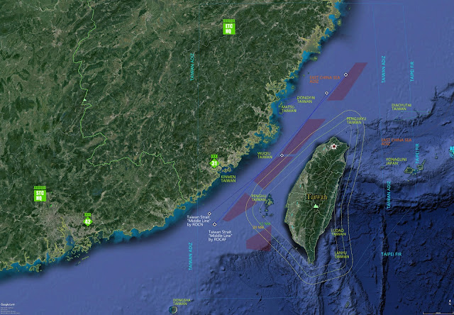
Basic information of Taiwan Strait for military enthusiast

Taiwan Strait (Wikipedia) information
for Military Enthusiast.
A strait between Repubic of China (R.O.C./Taiwan) and People's Republic of China (PRC).
The narrowest part between ROC & PRC is 130 km (81 mi) wide.
ROC ADIZ, and yes, it is a very large area. Source: CAA, MoTC, Taiwan, R.O.C.
Taipei FIR (Flight Information Region)
Middle line (Blue), ROC Air Force version. Source: Wikipedia. (Chinese only)
Middle line (Dark blue), ROC Navy version. Source: Wikipedia. (Chinese only)
Major islands.
Dongyin: 26°22'06.94" N 120°29'17.56" E (< 50 km to mainland China)
Matsu: 26°11'15.61" N 119°57'52.86" E (< 15 km to mainland China)
Quqiu: 24°59'14.46" N 119°27'29.54" E (< 30 km to mainland China)
Kinmen: 24°27'07.37" N 118°21'40.91" E (< 10 km to mainland China)
Penghu: 23°29'14.09" N 119°33'48.94" E (< 140 km to mainland China)
PRC East China Sea ADIZ. Source: Xinhua News Agency.
Additional information:
Distance to Yonaguni Island of Japan is around 110 km.
No comments:
Post a Comment