Air base/airstrip on the distributed islands in South China Sea
Look what islands are now accessible by airplanes.
Airstrip:
Paratas Islands (Taiwan), 20°42'10.21" N 116°43'18.25" E
Itu Aba Island (Taiwan), 10°22'35.34" N 114°21'55.97" E
Thitu Island (Philippines), 11°03'09.07" N 114°17'01.46" E
Spratly Island (Vietnam), 8°38'39.69" N 111°55'09.63" E
Swallow Reef (Malaysia), 7°22'20.64" N 113°50'37.41" E
Air base/Airport:
Woody Island (China), 16°50'07.05" N 112°20'33.17" E
Fiery Cross "Reef" (China), 9°32'58.96" N 112°53'23.49" E
Subi "Reef" (China), 10°55'27.73" N 114°04'56.18" E
Mischief "Reef" (China), 9°54'32.71" N 115°31'52.88" E
For other Information on those islands:
Pratas Islands: Wikipedia
Paracel Islands: Wikipedia
Spratly Islands: Wikipedia
Wednesday, February 8, 2017
Tuesday, February 7, 2017
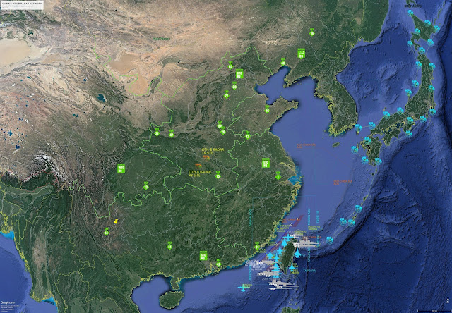
Chinese over-the-horizon backscatter RADAR
OTH-B sites (Tx and Rx) in Hubei province
Site locations:Transmitter site: 32°20'11.28" N 112°42'29.56" E
Receiver site: 31°37'09.15" N 111°55'07.52" E
Source: China's OTH Network, Sean O'Connor. http://geimint.blogspot.tw/2010/05/chinas-oth-network.html
Overview of Transmitter site: 32°20'11.28" N 112°42'29.56" E.
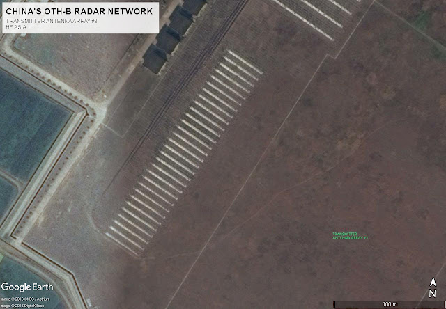
It is clear that there are 3 groups of transmitter antenna array at this site, therefore theoretically, at least 3 radar signals and on 3 different radio frequencies can be transmitted from this site simultaneously.
Each group of antenna array can also be divided and used by multiple transmitters, so that more radar siganls can be sent out from this site simultaneously.
Group of transmitter antenna array #1, consisting of 8 high-gain large log periodic antennas (LPA) for low to high frequency operations.
The 4 equipment rooms on the left might be accommodating 4 (or more) high power HF transmitters and phase combining network in order to provide the maximum transmitter output power. An array of 8 LPAs also provide higher antenna gain and plus high transmitter output power for the maximum effective radiating power (ERP).
The transmitters in the 4 equipment rooms and the 8 LPAs can also be divided and used individually, or in different paired combinations for multiple carrier/frequency operations. Actual signal analysis shows that the transmitters and LPAs are paired for 2 carriers/frequencies operations.
The LPAs of this group are installed so closed to each other, wonder if there's any RF coupling issues.
Transmitter antenna array #2, consisting of 30 LPA but for higher frequency operation.
Transmitter antenna array #3, consisting of 30 LPA(?) but for even higher frequency operation.
Receiver site: 31°37'09.15" N 111°55'07.52" E
60-degree sector (assumed) beaming to 120 degrees south east, 700 ... 3500 km coverage. Needs another 400 km to reach Guam and Saipan.
How about coverag for rest of Japan? Well, there is another one building in the Inner Mongolia of China. right now.
New OTH-B site found in Inner Mongolia autonomous region
Receiver site location: 41°25'05.88" N 111°04'21.99" E, anyone knows where the transmitter site is located?
A combined 700 ... 3500 km coverage of both Hubei and Inner Mongolia sites will be like the photo below, The Inner Mongoloia (Rx) site has a 60-degree sector (assumed) beaming to 100 degrees south east.
Shuimen Air Force Base, Xiapu, Fujian. (PLAAF)
Shuimen Air Force Base, Xiapu, Fujian. (PLAAF)
An overview to the area:
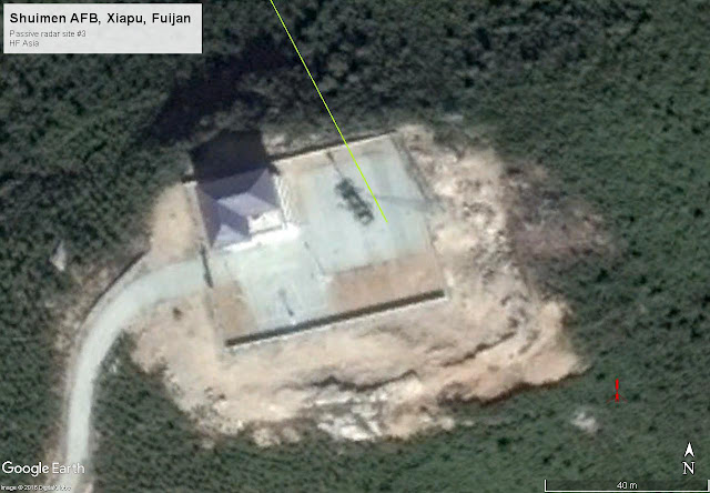
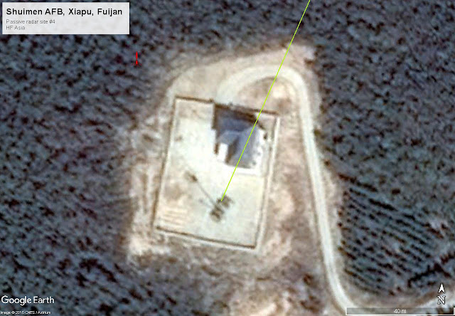
Shuimen AFB Passive radar network
Passive radar network including 4 passive radar sites and 1 control site.
Air surveillance radar site x1 (PLAAF)
Air surveillance radar site x1 (Unidentified)
HQ-9 SAM site x1, including a HT-233 fire control radar.
And a site with probably 3 microwave antennas (2 with antenna radomes), could be an electronic support (ES) site.
The direction of the red line is pointing to the Diaoyutai/Diaoyu/Senkaku Islands in the East China Sea. It has the same pointing direction as the airport's runway.
Maybe this aiprort is dedicated for the Diaoyu Islands, as they normally don't put such expensive Sukhoi fighter close to the coast line of Taiwan Strait, this AFB seems to be the only exception.
The radar is installed in a shelter of a vehicle, and there's a telescipic mast for mounting the radar and data link antennas. All passive radar vehicles should have the same configuration except 3 data link antennas/ transmission systems (Comm node) are required in site #1 in order to obtain the received target data from the 3 sites deployed in the front.
Passive radar site #3.
Passive radar site #4.
Thursday, February 2, 2017
PLA Large Phased-Array Radar (LPAR) 2500 km coverage
PLA Large Phased-Array Radar (LPAR) 2500 km coverage
90-degree sector, Heilongjiang & Zhejiang sites:
90-degree sector, Xinjiang site:
For most of the time, the antenna face is beaming 185 degrees south, for an obvious reason.
Combined 90-degree sectors, Heilongjiang, Zhejiang & Xinjiang sites:
So, where is the missing one? In Sichuan? Or go further to the north?
PLA OTH surface wave radar network for the Taiwan strait
PLA OTH-SW radar network site locations
Site 1: (from top down)
TX site: Wenzhou, Zhejiang, 2 transmitters, 2x Log Periodic Antenna Arrays (LPAA).
RX site: 1x Monopole antenna array.
Site 2:
TX site: Fuzhou, Fujian, 2 transmitters, 2x Log Periodic Antennas (LPA, single antenna).
This is the only transmitter antenna configuration in the radar network, only one LPA
is used per one transmitter.
RX site: 1x Monopole antenna array.
Site 3:
TX site: Zhangpu, Fujian, 2 transmitters, 2x Log Periodic Antenna Arrays (LPAA).
RX site: 1x Monopole antenna array.
Site 4:
TX site: Guangdong, 2 transmitters, 2x Log Periodic Antenna Arrays (LPAA).
RX site: 1x Monopole antenna array.
Construction took place in 2014 to relocate the Control and RX sites that are close to a nearby developing industrial park.
PLA OTH-SW radar network and its 300 km coverage
The radar detection range shown below is based on Russian Podsolnukh–E OTH-SW radar specifications (300 km for Aircraft carrier type surface targets).

Transmitter beaming direction is determined by measuring TX LPAA pointing direction at each TX site and except for site 2 with only 1 transmitting direction (60 degrees coverage sector shown), the coverage for rest of the sites are a comination of 2x adjacent 60-degree sectors (120 degrees) which result from the use of 2 independant LPAA at the transmitter site as shown below.
According to radio frequency observation, the colocated transmitters can be operated simultaneously, and the networks normally operate below 10 MHz.
Normally, all the Chinese OTH-SW radars will be up at the same time using different frequencies, and their OTH-B radars will be operating simultaneously.
Source:
OTH-SW site locations: China's OTH Network / Sean O'Connor
http://geimint.blogspot.tw/2010/05/chinas-oth-network.html
Basic information of Taiwan Strait for military enthusiast
Basic information of Taiwan Strait for military enthusiast
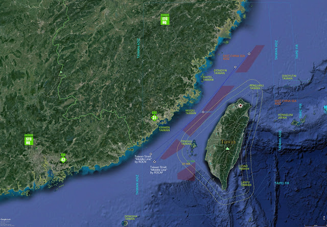
Taiwan Strait (Wikipedia) information
for Military Enthusiast.
A strait between Repubic of China (R.O.C./Taiwan) and People's Republic of China (PRC).
The narrowest part between ROC & PRC is 130 km (81 mi) wide.
ROC ADIZ, and yes, it is a very large area. Source: CAA, MoTC, Taiwan, R.O.C.
Taipei FIR (Flight Information Region)
Middle line (Blue), ROC Air Force version. Source: Wikipedia. (Chinese only)
Middle line (Dark blue), ROC Navy version. Source: Wikipedia. (Chinese only)
Major islands.
Dongyin: 26°22'06.94" N 120°29'17.56" E (< 50 km to mainland China)
Matsu: 26°11'15.61" N 119°57'52.86" E (< 15 km to mainland China)
Quqiu: 24°59'14.46" N 119°27'29.54" E (< 30 km to mainland China)
Kinmen: 24°27'07.37" N 118°21'40.91" E (< 10 km to mainland China)
Penghu: 23°29'14.09" N 119°33'48.94" E (< 140 km to mainland China)
PRC East China Sea ADIZ. Source: Xinhua News Agency.
Additional information:
Distance to Yonaguni Island of Japan is around 110 km.
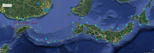
JASDF Radar & Troposcatter Networks
JASDF Radar & Troposcatter Networks
I was not able to find the troposcatter link of 43rd AC&W Sqdn due to low Google Earth map resolution along the link path. Please let me know if you have the detail.
Also, a troposcatter antenna photo was released in a news reporting the first time military deployment in Yonaguni Island by Japanese Self Defense Force, but no deployment of Air Surveillance Radar is mentioned.
New Chinese OTH-B Rx site identified
New Chinese OTH-B Rx site identified
Anyone knows where the Tx site is?
See also China's OTH-B Radar Network:
http://hfasia.blogspot.tw/2017/02/chinas-oth-b-radar-network-site.html
Is that really a LPAR at Hui'an site in Fujian?
Is that really a LPAR at Hui'an site in Fujian?
It really looks like a (PLAAF) LPAR from the begining.
Is that a vehicle/shelter in front of the LPAR? Better not to do this
Put another antenna Radome in the front? It doesn't seem to be a good idea. There are lots of free spaces available at the site.
A good place for the new antenna radome. They can also use free apaces of PLAAF site, and PLAN site above, on top of the mountain, if they can get alone with them.
If Hui'an LPAR is real, it will have a 60-degree/2500 km assumed coverage as shown below in red, it is basically the same beaming direction as the Zhejiang LPAR site, which the face of LPAR antenna array is fixed to 160 degrees south.
According available Google Earth map data, the Hui'an LPAR antenna is facing 150 degrees south, and there's no any sign that it is a rotable one.
Chinese Large Phased-Array Radar (LPAR), where is the missing one located?
Chinese Large Phased-Array Radar
(LPAR), where is the missing one located?
Hebei 7070 Radar (dismantled): 40°26'48.33" N 115°06'59.69" E
Xingjiang: 41°38'28.33" N 86°14'13.29" E
Zhejiang: 30°17'11.12" N 119°07'44.45" E
Fujain: 25°07'35.27" N 118°45'06.06" E (Is that really an LPAR?)
Heilongjiang: 46°31'39.29" N 130°45'23.12" E
Any one knows where the following LPAR site is located? Based on the covrage of the three identified LPAR sites (http://hfasia.blogspot.tw/2017/02/blog-post_50.html), the Chinese definitely needs another one to cover the space of South East Asia, could this be the one?

Please let me know if you have the location info. Thanks.
Subscribe to:
Comments (Atom)

